PubTalk-06/2023 Next Generation Topographic Mapping
hello and thank you for joining us for tonight's USGS public lecture we are happy you have taken an interest in the USGS science my name is Mitch and I will be your host and moderator today I have some quick announcements to make before I introduce our speaker next month's public lecture will be on July 20th 2023 when Andrea Creighton from the U.S water science center will talk about snowpack Dynamics so please remember to join us at 6 PM Pacific Time on July 20th if you are watching this from a desktop computer and they need to turn on closed captioning please look at the bottom right hand corner of the screen for the closed caption icon it's the one with the two little C's you can also use stream text for captioning please see the stream text link provided in the question and answer window to access that question and answer panel you can click on the question mark icon in the upper right hand corner of your screen at the end of the lecture we will have a question and answer session and this is the panel where you can submit your questions to a speaker and now it's time to introduce you to tonight's speaker joining us tonight is Ariel Dumbo yay Ariel is a cartographic products lead for the U.S geological surveys National geospatial program Ariel has worked for the at the USGS for 15 years with the background and passion in geographic information systems water and cartography in her current role she provides leadership for USGS topographic map products including technical guidance map design map content and future capabilities without further Ado I'm going to pass it over to Ariel all right hello telethers and to all of you for joining this presentation again my name is Ariel dunboya and today I'm going to be sharing information with you all on some of our existing topographic map products as well as some advancements in the USGS topographic map offerings which are available to you all right now before we get going here is a little bit more about me and an overview of the topics that I'll be covering today I am based out of Denver Colorado but was born in Alaska and still consider that home in 2008 I started with USGS as a student and have worked in both our hydrography and cartography programs for our agenda today I'll do my best to keep the history lesson brief and the technology information will be sprinkled throughout the presentation what I'm really hoping you all come away with is information on our historic current and our newest digital topographic map products as well as how to find them access them where to learn more and why this is important for USGS and you as consumers of our products and services the USGS was entrusted with mapping the nation in 1879 and has been the primary civilian mapping agency of the United States ever since this Heritage was largely established by John Wesley Powell the second director of USGS USGS topographic maps fall into three primary product categories first we have the historical topographic map collection or htmc and this is the set of scanned images of USGS topographic quadrangle Maps which were originally published as paper documents in the periods from 1884 to 2006. U.S toppo is our second product and is the current USGS topographic map series for the nation these are modeled on the Legacy seven and a half minute Maps but are mass produced from GIS databases of the national map and published as digital documents the last category is on-demand toppo and on-demand topos are USGS style topographic map created using the Topo Builder application these maps are generated upon request using the best available data from the national map and offer customizations such as choice of format area of interest and National map content the mission of the national geospatial program where I work is to provide National topographic information to advance science support government enlightened citizens and enable decision making we do that by providing a foundation of Digital geospatial Data representing the topography natural landscape and man-made environment of the United States the national geospatial program has many components which include things such as the national map the 3D elevation program National hydrogracy and Geographic names to name a few today we'll be focusing on the national map the national map was formed in the early 2000s as a means to establish a seamless continuously maintained set of public domain Geographic based information the national map currently consists of eight data themes and a variety of federal Partnerships exist to support the national map to ensure National consistency and authoritative data is represented within the data Holdings our goals are to serve the geospatial community by providing high quality integrated geospatial data and improved products and services including our new generation of digital topographic maps so who contributes to the National map the national map data is a collaboration from local state and federal agencies these agencies work with USGS to ensure the data is up to date and ready for things like U.S Topo production as you can see there are a lot of contributors that make the national map what it is today so what are the eight base layers of the national map those layers are elevation which is used to generate Contours and shaded release hydrography Geographic names land cover boundaries transportation structures and imagery ultimately these eight base layers come together to create the content found on USGS topographic maps data in support of the national map as well as current and past U.S Topo
products can be found and downloaded anytime through a web application called the national map downloader now let's talk a little bit about USGS the USGS historic topographic map collection or again htmc the historical topographic map collection is the group of all USGS topo maps these Maps were produced as early as the 1880s and are available in several scales Nationwide as of today there are approximately 185 000 scans available through digital repositories to the public at no cost historical topographic maps range in scale and extent from 1 to 24 000 to 1 to 250 000 scale it is important to note that htmc maps are not layered PDFs but a flat scanned file they do however include a metadata attachment the files are captured using consistent high quality specifications to preserve the print resolution and are offered in multiple formats as all files are geo-referenced meaning they are tied to a known Earth coordinate system these Maps can be imported into GIS systems for analysis or used on your mobile devices USGS is continuing to scan and release additional scans of historic USGS topographic maps as additional items are identified as missing from the collection in some cases the original scans were not as high quality as the specifications required or some geo-referencing and metadata errors existed these scans are also being corrected as the errors are identified I'd like to note that these errors are a natural occurrence and relatively rare due to the automated and semi-automated technologies that were used in the original processing of the bulk of the collection USGS welcomes customer comments on any errors identified in the collection as we wish to ensure high quality and consistency of these Maps historical topographic maps can be found and downloaded through a web application called Topo View Topo view provides not only historic topographic maps but also current US topos for download to use the Topo View application first set the date slider and map scale in this case I've selected 1880 through 1950 and 100K scale zoom in and select your desired map and then click on the format link to download shown in the red box here is an overview of our main webpage for the USGS historical topographic maps if you'd like to learn more FAQs are frequently asked questions are linked from the htmc webpage and provide valuable information on a variety of topics the htmc webpage also includes links to our latest fact sheet and users guide from the 1880s through the Advent of computer technology topographic maps have served as the essential instrument for the integration and Analysis of place-based information USGS mapping techniques evolved over 140 plus years from field surveys to photogrammetry to the gis analysis currently in widespread use this forms the basis of the technology behind our historic topographic map collection our U.S Topo program was a transition to a more modern digital production that leveraged process automation through server infrastructure production to a distributed Cloud environment this enabled the use of big data and relational data and in addition USGS was able to streamline and stabilize our production processes to create more consistent products so now let's talk about the results of that technology advancement and where we are with our U.S Topo program so let's begin with the basics what is a U.S Topo anyways so U.S topos are digital USGS topographic maps these are modeled from the traditional seven and a half minute paper maps which were produced from 1880 through 2006. U.S topos are regularly updated to
provide the nationally consistent coverage from its start U.S topos were updated every three years with some exceptions in Hawaii Alaska and the U.S Virgin Islands going forward U.S topos will be produced on a new schedule based on content changes every map includes imagery shaded relief transportation and hydrogracy as well as other data layers U.S Topo products are one to twenty four
thousand scale topographic maps produced for the entire United States they are free and immediate downloads to anyone but there is no customization options and they are created in preset seven and a half minute quadrangles U.S topo maps are created through a semi-automated workflow with most of the manual components being tied to annotation which is how we put our labels on the maps and quality assurance review and checks we have historically produced one-third of the country each year so that means the maps were always no more than three years old so looking at a little timeline here the U.S topos were publicly launched in December of 2009 and the maps were initially published using the terrigo Technologies patented format of geopdf in 2013 the first Maps outside of the continental U.S were added these included Hawaii Puerto Rico the U.S Virgin Islands and Alaska for a variety of technical reasons USGS made a decision to move to a geospatial PDF format in 2014. 2017 marked another huge milestone for the program with the modernization of our production systems which included setting a standard scale extent projection datum coordinate system and grid information this modernization helps the USGS ensure that all U.S topo maps had the same
cartography page layout layering metadata and other characteristics this modernization set the stage for where we are today with Topo Builder GIS based cartography and remotely collected Source material really enabled automated processes and decreased our map production time from hundreds of hours to about a day the U.S Topo program strived to republish all of the 55 000 maps in the continental U.S Hawaii and Puerto Rico on that three-year cycle while adding over 10 000 additional maps at a scale of 1 to 25 000 in Alaska the first three-year cycle was completed in 2012 and Alaska was completed in 2021. this required the USGS to continually produce approximately twenty thousand topo maps each year U.S topos are created using consistent
high quality specifications and metadata information is specific to that map for example if no wetlands are within the map extent that information will not be in the metadata as with htmc all files are geo-referenced so these Maps can also be imported into a GIS system for analysis or use on a mobile device some limited interactive PDF capabilities are available which you can learn about on our website or from our training videos USGS is continuing to produce and provide new U.S topos these maps are available to users at no cost and can be downloaded immediately as stated earlier U.S topos require a specific standard be applied to the product which includes content USGS is continually evaluating and adding appropriate content as data is identified to meet the identified specifications within this category USGS and our partners have made significant updates to data over the Pacific territories of the United States with these data improvements USGS plans to incorporate the Pacific territories into the U.S Topo production schedule
wherever data now meets our specification in addition USGS is continuing to evaluate opportunities to improve and automate our production processes in order to deliver timely high quality standard National coverage of topographic information to users this is the main web page for us toppo and this is a great resource where you can find updates on the U.S Topo production other USGS topographic maps as well as information on our national map data themes this page also includes announcements for new activities the national geospatial program has also released a series of how-to videos for people who are working with the national map products data and services the link in the bottom right will take you to the main site for all training videos click on the link for topographic map videos to see videos specific to us toppo and the historic topographic map several U.S Topo how-to videos are available and some examples include a U.S Topo overview printing us topos and using U.S toppo and historical topo maps on your mobile device similar to the htmc webpage the US Topo webpage also has frequently asked questions linked from those FAQs more information can be found within the U.S topo maps General
topographic maps and geospatial data topics along with the FAQs linked on the web page users can find additional information on U.S topos from the linked us toppo users guide as part of the U.S Topo products a fact sheet and product standard can also be accessed from the web pages the fact sheet is a concise overview of the U.S topo maps and the mapping
program itself the product standard contains technical information about the layout and marginality of the maps such as those grids projections extent scales and it also includes information about data quality data sources and metadata so there are four USCS sites where topographic maps can be downloaded the national map viewer the national map downloader topoview and the USGS store now I'm going to provide a very quick overview of these sites with the exception of Topo view which I've already shown first the national map viewer can be used to view the exact publication dates and access the latest U.S topos the U.S Topo availability service allows you to select U.S topo maps for a specific area and see the most current publication date as well as directly download the files secondly the national map downloader is really our primary application for searching and downloading maps and Digital geospatial Data there are a variety of tutorials and videos on using the national map downloader from the NGP Training Site shown earlier lastly the USGS store has several search and download features you can use the products drop down to select map categories and search for those items by keyword country or region the USGS store offers free downloads and sells printed Maps the USGS store also offers many USGS maps and Publications that are not included in either the U.S Topo or historical topographic map collection although the focus of this presentation is on digital topographic maps I also wanted to mention for awareness that the national map provides a multitude of web services that can be used in a variety of web-based platforms this includes base Maps theme or data overlays as well as other offerings that can be used in GIS desktop or online software as well as in a standard web browser and even with apps on mobile devices and of course I had to put up an example of our Topo based map over Wrangle San Elias which is where I grew up as with the other information I've shared there is a web page that will take you to more information on our data delivery and web map Services as well as take you directly to that list of services that I had shown on the previous slide now back to the technology piece a little bit so the foundation of the U.S Topo modernization has set the stage for our newest product offering which is really building on top of that server infrastructure to distributed Cloud production with that big data and this is allowing us to rapidly disseminate data and products to our end users all of you in a fully automated environment so now on to our newest product offering so in early 2022 the U.S Geological Survey launched a new
topographic map production system the production fish system is 100 automated allowing users to request topographic maps with the best available National map data and receive their maps by email usually within 24 hours today I'll be talking about the advancements and modernizations that the USGS is continuing to develop to support your topographic mapping needs so the web-based application is called Topo Builder and it currently allows users to request customizable USGS topographic maps users can request a map when they want where they want and with the data content they want the delivered map product is called an on-demand Topo and it is available in addition to our staged us Topo products and our htmc files the on-demand Topo products will not be replacing the us topos but will supplement them by allowing users to access the most up-to-date data content in an on-demand environment this means we are making maps for you where you want the way you want and all of this is at no cost to the public so before I talk about the development path and demo the application let's do a quick review of what you're getting with an on-demand Topo so shown here is a popular place called Horseshoe Bend within the Glen Canyon recreation area on the Colorado River U.S topo maps are split up around the bend but what if you want to see it all on one single topographic map with on-demand toppo users are currently still Limited excuse me to a seven and a half minute quadrangle equivalent extent but the user can Center their map over their area of Interest they're not limited to the predefined quadrangles of U.S Topo these maps are generated on demand using fully automated procedures and and demand topos offer more recent data than U.S topo maps
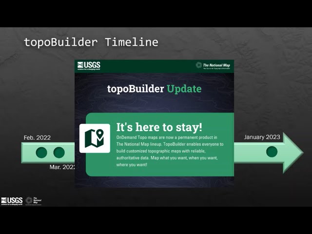
so a little bit of timeline information before we do the demo to show where we've been for about the last year and a half so for our initial launch in February of 2022 we had an initial set of customization options but we weren't really sure how it would be received we decided to do this as a public pilot to see if this was something that users would really want and use right after the release we started getting feedback from users and so we significantly improved the application for use on a mobile device then in may we added the option for users to choose which national map data layers they want they wanted included on their Maps from there we noticed some users were having issues with notifications so we made some improvement and we also improved our process related to shaded relief generation which is also done on the Fly and then in December we hit another big Improvement Milestone related to customer feedback and added an option for users to track any of their maps and orders directly from the Topo Builder application then in January of this year after a highly successful pilot we made a decision to make Topo Builder and the associated on-demand Topo products a permanent offering from our program this means we will continue to support this application and be developing additional capabilities for you all to create more types of maps with even more customization options so before I continue on to the demo the purpose of presenting this timeline information is to show that the system is new and evolving we are actively developing additional map types and additional customization options so if you don't see everything you might want or need in this demo please check back or send us a message as shown with that timeline and the customer feedback items this is a system that has been and continues to be influenced by users this application was built with the users in mind and your messages to us whether they be complaints about the time to receive your map or kudos for the great improvements to the trails data we are listening and paying attention to that information and we are using it to inform our future plans so now let's get to the fun part and learn how you can request your own topographic maps I will be using slides for the demo but please feel free to follow along at Topo builder.nationalmap.gov when you first launch the application from a web browser you need to First choose your map type currently the only map type is the seven and a half minute on-demand Topo but as I stated earlier additional product options will be added in future development Cycles the seven and a half minute Topo will be selected by default so there's no need to click to select it simply click the next button to confirm and continue with your selection once you clicked next you will move to the maps tab from the maps tab you'll need to search for an address or location or Zoom to your area of Interest the application will guide you with a message to select your area of Interest or zoom in to display the grid there are currently two options for map extend with custom select which is selected by default you click anywhere on the map to create your own seven and a half minute extent shown here in blue or to make an on-grid map choose the select by grids button then click one of the preset seven and a half minute grids shown as an orange or yellow box here so once you've selected a map or multiple Maps you can select the edit layers option to select which national map data you would like included on your output map simply uncheck any layers you do not want included on your Maps a user-defined Content tag will appear in the map card and Maps will be delivered to you with a user-defined Content note in the marginalia letting you know that the content was modified it is important to note that this setting applies to all map products in a single order every map in this order will have the same set of custom layers to create maps with different custom layers simply check out and start a new order once you've chosen your layers you can select your map format note that the user defined content tag has appeared after selecting the custom layers in the previous slide our current format options are geospatial PDF or geotiff geospatial PDFs have limited mapping functions like find XY coordinates and measure distance and can be viewed and printed without specialized software this format is ideal for non-gis specialists geotiff includes geo-referenced information as just as with the geospatial PDF and it can be used in GIS software as well as image editors the other customization currently available is Contour smoothing simply click on the info icon to see detailed information on the Contour smoothing options low means the Contours will be very detailed with the least amount of smoothing medium is the default option and will produce Contours most similar to what you may have seen on our us Topo products and high means the Contours will be very smooth use the slider to select the appropriate smoothing level based on your needs now back to the demo so once you have confirmed your customization options and added your maps to the cart map or maps to the cart by checking the check box next to the map name and then clicking the add button please note that multiple Maps can be selected and if desired a subset of your Maps can be added to the cart this example shows one map but I just wanted to make sure you knew you could request multiple maps at once so note that the counter next to the word cart tracks the number of items you have added to the cart your selected maps and their customizations will be listed here to change the Contour smoothing or format for any map in the cart click edit Maps just remember to click save if you've made any changes to your maps in the edit interface either the save or cancel button will take you back to the cart once you're finished adding maps to the cart click the checkout button a dialog box will appear asking for your email address input your email address and simply click checkout you will see a confirmation dialog box and the system will begin processing your map you will receive a confirmation email shortly after checkout this email includes individual information about each map in your order including the type of map and all of the customizations you chose Topo Builder does have a five-day time frame to complete a map your map request will be completed within five days and usually much sooner we are currently averaging a less than 24 hour delivery time once your map or maps are ready you will receive a second email with a direct download link the file will be available to download for 60 days and the link expiration date is in the email the map delivery email can be shared with friends peers or co-workers who can also download your map from the same link at any point after placing it an order you can track its status using the order confirmation number given in your confirmation email within the Topo Builder application go to the track tab and enter your order number and then click track the tracker will show you what state of processing your order is in and if it was delivered on what date multiple orders can be tracked at the same time just enter another confirmation number in the Box if you do not receive your map within five days please contact our help desk by clicking the envelope icon in your confirmation email so now that we've completed the demo I wanted to go over some of the similarities and differences that are important to know about when you're choosing whether you want or need a us toppo or an on-demand Topo so both products currently use a similar standard and specification so these products have a familiar look and feel if you're used to the US Topo products U.S topos offer only the standard USGS seven and a half minute quadrangle extents whereas U.S on demand topos excuse me offer that and the custom extent or Center Point option U.S topos have pre-designed Contours based on a specific set of criteria and ranges where the on-demand topos generate the Contours on the Fly meaning they could be for more current data than what is seen on a U.S Topo
U.S topos have historically been produced on that three-year cycle so depending on when that map was created the data could be up to three years old with on-demand topos you are getting the best available National map data that we have within our Holdings U.S topos are staged Maps meaning they have already been created and are available for download at any time on-demand topos are created upon requests so these are only created when you ask us to Via the Topo Builder application either way you can download or request as many Maps as you need at no costs and then here are some more important similarities and differences to consider related to scales and availability across the United States so we have similar skills for the continental United States and Hawaii as well as Alaska and some of the territories but you will notice that on-demand topos offer more availability for requesting Maps than U.S Topo currently offers over the Pacific territories last U.S Topo is only produced at the skills listed while on demand topos have multi-scale Maps currently in research and development so not quite yet available but in research and development now I'm just going to do a quick click-through comparison so you can see some of the key differences between these products the logo or identifier is the first place to look to identify your product the credit note has slightly different information based on how and when the product was produced the labels may appear slightly different based on the automatic labeling that is applied to the on-demand topos and the labels could be slightly less dense and the Contour and Trail symbology may appear slightly different or you may be seeing newer data with the red trails that are shown here than you would on the associated U.S Topo product so we've done the demo and we've talked about the pilot and now you have some basic information on how these products are similar or different but how has this all been going well in the past year and a half we've seen requests covering all states and territories we have produced and delivered over 300 000 maps to over 72 000 unique users so why is this so important if we look back at the history of our program and the advancements in technology we were able to improve our production Cycles from years to months to weeks to days to hours but still in order to complete the entire nation we were still looking at three years to publish that entire nation of about 65 000 Maps with Topo Builder and the technology we are now using we can produce and deliver about 20 000 Maps per month compared to 20 000 U.S topos per year
so now that you're all hopefully excited to try out Topo Builder you may already be thinking about more customizations or other map types you'd like to see well as we look forward we are already developing that next product which will be a one to one hundred thousand Scale map called a 100K Topo this is the first time since the early 90s that USGS has produced maps at this scale these maps have many purposes for things such as Regional planning and Land Management but also just provide a really great view of a larger area with slightly less content if that's what you're looking for we also have additional customizations planned such as print allowing users to add data from other sources and GIS data download to name a few and we will continually be looking at how we can make the application easier to use this is a system that we have designed for anyone we do not want users to have to have special skills or special software to create these Maps we want the application to be as friendly as possible to help you get the maps that you need and just one more web page for you all if you'd like to learn more about Topo Builder or the on-demand topo maps we also post and share updates here as new products or customizations are made available so I already talked a little bit about why this is important or significant for users but let's take a moment to talk about why this matters within the USGS and within the federal government what we're doing now with Topo Builder is more than just getting Maps into users hands and it isn't just about mapping the nation anymore it's about how we can use the rich history of topographic mapping at the USGS with the advancements in technology to really improve the status quo this means we are changing how we work internally we are more focused on the value add that our map products can provide we want to make an impact we want our products to make a difference for those who use and need them and to do that we've needed to shift our Focus to more Innovations at the end of the day as a public servant my goal is to have an impact my goal is to make a difference and with this system we are really looking at how we can build great software using Cutting Edge Technologies and try to solve these problems to get you the best information and the best maps that we can Topo Builder is still in its infancy so how we continue to develop this system and meet these Innovative initiatives is something that we ourselves are continuing to develop and learn if you want more we do too and we are working diligently to add more to the system if we don't have everything that you want today please check back please visit our website follow us on social media and we will keep you updated on new developments with this part of our program so we've looked at where we've been and where we are but what does the future future hold um so artificial intelligence or AI is the next stage of innovative technology within geography and cartography we call this goai in the future GOI AI capabilities will be able to use deep learning to simultaneously operate multiple machines in the cloud each with a large amount of data and memory to serve geographical information this has major applications to improve modeling planning resource allocations and decision making we do have a team of researchers within USGS that are looking at machine or deep learning and I'm excited to see what the application of goai can and will mean for the USGS and our mapping programs so with that I hope you all give Topo Builder a try and maybe even check out some of our other products if you haven't before and if at any point you have any questions or needs support please feel free to reach out to our national math help desk or our national map Liaisons these folks are friendly and responsive and are truly invested in the customer service side of our work and they have a wealth of knowledge and information to assist you so now I'd like to open it up to the team coordinating the session to facilitate our q a thank you so much for your time and attention it would help if I UNM unmuted my mic thank you Ariel that was great talk um I've been a mapper mapping for 30 some odd 30 plus years here at USGS and I learned a whole bunch so thank you um before we begin our q a portion of the lecture just a friendly reminder if you would like to submit a question please click click on the question mark icon we've been monitoring questions that have come through so far and I will go ahead and ask those out loud first and we will do our very best to get all your questions so um one of our first questions with someone asked is what are the standard dimensions if I want to get a map file printed at the print store so I should have had this handy on my desktop I can't remember the exact page size of the file off the top of my head but if you email that tnm help desk they'll be able to answer that question for you within minutes it is somewhere around 27 by 30. that's varying based on where you are in the country some slight variance there right um they had a question that somebody was asking if the talk slides are going to be made available to attendees um I have sending my email and I will hopefully you know get back to me and I can send them off to him um somebody else that asked about the national map Services link didn't work the one you had so I gave them the the correct ones I think we're over there uh let's see we're getting a couple more questions um compliment was very well done Ariel you rock uh let's see um thank you for your lecture how could the USGS impact future Generations could these topo maps reach African countries as well so the mission of our program is to map the United States there are other parts of USGS that do provide maps for other areas of the world but within our program specifically our mission is the United States right okay I'll see in the past topo maps I made contain the names of the landowners now I can't see this option please advise yep that is correct so historical topographic maps do contain different and in some cases more information than our current U.S Topo products do um so that is part of the content changes that I discussed where we are continually and continuously evaluating content to see if that's something that we can add back to the maps but as of right now you are correct that data does not exist on our current products interesting I didn't know it was there to begin with um okay I don't think we have any more questions at the moment I'll give people a couple of minutes or so to see if they have any other questions um it's really nice to see how this program has advanced in the last couple of years I was on the I was on the team doing the initial evaluations and it has improved dramatically since then um okay uh another question is aerial photography still used with making these Maps so um we do have aerial image imagery that is included on the products that comes from the national agricultural imagery program from the USDA so all of our U.S topos do include imagery our on-demand topos include imagery as well and you have the choice of whether you'd like to turn that on or off with the layer control within Topo Builder hopefully that answered your question yes I think it did okay okay um yeah there's a let's see will there be an option to use historical data along with current data to view changes over time so I love this idea this is something that has been asked before and one of the things that we have looked at within the Topo Builder platform is whether we can provide an option for a user to choose their own base map so they could choose a historical map and the great thing about Topo view is you could select right from that date site or choose any date that you want put that in as your base map and then just layer the current data on top however if your question is about are we going to be providing historic data available that is something that we have researchers looking into how we can extract features from our historical topographic maps but we haven't quite gotten to the point of figuring out whether that research will be fruitful enough for us to make that data itself available again let me know if that didn't answer the question oh I think I think that did let's say um let's hang on here um or is there any way to make reprints of past yeah somebody's asking any way to make reprints of the past versions with the landowner information I think you covered that yeah as of right now because of the the requirements and standards that we have for nationally consistent authoritative data across the entire nation and a similar standard and spec that information is not something that we can immediately add back to the topos now one of the things that we have looked at with the user added data for Topo Builder which is something that is still in development is if we there was a way for you to find an authoritative source for that if you could put that on top of your on-demandobo so that may be a capability that becomes available in the future and not just for land ownership information it could be a variety of other data we've had people who want to add weather data animal Migration patterns species information things like that and so we're really in the research phases of figuring out how we can add that content but that could be an option for that this person who's asking the question in the future okay okay good let's see um a bunch of questions here um how do you rectify the Border vaults how do we rectify the Border fault not quite sure what that means yeah I apologize if I'm not understanding that question that would be another one I would suggest if you'd like to send us a follow-up that's our tnm help we can try and get you an answer to that one okay um let's see are there any areas restricted area 51 or Washington DC or any other areas um is noted on the map so they just omit details okay so we do have a FAQ posted on that USGS website about this exact topic for the U.S Topo products themselves there are some areas that are not included in the U.S Topo collection and
that is not because it's Area 51 or some type of secret facility it's because there is no nape that National aerial imagery program data that I mentioned earlier available in those areas U.S Topo has a very specific set of criteria and specifications that have to be met and because there is no imagery those maps are not produced now however with Topo Builder you can go in and request those Maps they may be missing imagery if you're overlapping one of those areas you may have partial imagery but you can absolutely request those maps from the on-demandobo or Topo Builder system okay good can you save a custom extent like save it to reuse multiple times if that's the question so if you want to reproduce the map of the same exact custom extent multiple times this is also something that another user has submitted so I love these questions um we have been looking into whether that's possible right now you would just need to click on the same extent and I understand it could be hard to click at the exact same X Y coordinates but as of right now that's the way that you would reproduce the same map multiple times if for example you wanted to see newer data but we have an item in our backlog to look at whether there's a way to kind of save the bounding box or something like that and reproduce that same map multiple times I hope I answered that question I want to make sure I'm fully understanding so let me know if not okay and from Aunt from an Andy s he says FYI maps in Kanas Hawaii and Alaska are 24 by 29 maps in the territories are 29 by 35 and a half thank you initiate that Andy I knew there were some variants okay and from Linda wants to know are there any plans to make to add geology to the maps so geology legitim where people could add geologic information just like they could species information or the other items that we mentioned and there's not any plans at this time to create a geologic specific map but we have been looking at how we can add geologic data on top of the other content through user added content okay I also point out to that person that they can check the national geologic map database as well there are tons of geologic Maps already available and those can be usually downloaded in order to your phone or laptop let's see is it clear how to make to take a map onto your phone is there offline mapping so you can download the map and use it with offline access but you will still need an internet connection to actually download the map and then use the GPS capabilities so that you can actually navigate on the map there's a really helpful video that we have that I one of the ones I highlighted before on how to do that it works with historic topo maps us topo maps on-demand topo maps I can't necessarily say every single app developer out there that we've tested every single system but it is very easy you can download it and use it for offline access but again if you're offline you may not have those those tracking capabilities to track your location okay um the other question was sorry I missed the first half hour our custom downloads geo-referenced yes they are all of the files file friends right um there are several third-party programs which are web-based such as caltopo comments on caltopo similarities and differences yes so we have looked at Cal toppo there's a variety of commercial options out there to do things similar to what we are doing and there's a variety of commercial Partners out there who are doing more than what we are doing or different things than what we are doing so I would say what's unique about what we have right now is um you know at least compared to our previous products you can do the custom Center Point you're getting access to the best available National map data so the best data that we have within our own databases and you have these customization options at absolutely no cost now what I would say I would love to see in the future is users or companies providers Etc like Cal Topo Gaia avenza some of these other companies looking at what we've done with Topo Builder and seeing if they can value add to it and if there's something else that they can add that would provide even more benefit for their customers and their user base okay I'll see another question was Data enrichment was mentioned will the source of the enrichment come from users or will it come from a USGS database on the USGS side for USGS data Holdings and most specifically National map data Holdings and so that will all be on our side unless I'm misunderstanding the question now again I would go back to kind of the user added content piece so if there's something you want to add to the map we want to expose that capability for you but we're looking at things like how can we make our data more map ready so that it's delivered to the system in a state that's optimized for map production so it gets to you faster how can we look at generalizing our data so that we can have multi-skill data to meet the requirements of those multi-scale Maps so that's the type of data enrichment that we're really looking at internally and it is in our national map data okay I'll see um is it possible to customize contour map Contour range colors oh that's a good one I don't think that's a request we've received before I it is not possible right now but I'm I will add a note for that we have a pretty big backlog but I'm going to add a note for that one because that hasn't been requested before and that might be a nice addition yeah okay let's see um one person asks what is the cost of getting a printed map and I think those are they're 15 bucks if I recall correctly yes from the USGS store but you're welcome to take your files elsewhere as well you can you know that video that I showed on how to print the maps actually shows different printing options whether you want it to print on a printer at home whether you want to print it out for other purposes so you can do different page sizes different printing options and order through the USGS store as as well as other private print providers okay I'll see and I got a bunch of other questions here I think I'm going to break it down to maybe one or two more here um you uh the person asked On the Border faults is where quadrangles meet but Line work doesn't match up I I think I'll still need more to be able to answer that question because I'm not sure what line work that would mean if it's the Contours we do have processes for our shaded relief and Contour generation process to essentially blend and smooth the Dem data but that's really more about elevation data collection than it is about fault lines so I just I I would suggest maybe sending a follow-up because I want to make sure I'm answering that question properly yeah yeah okay last question here um where did you get inspiration for topographic maps was it all from people's suggestions or did you also take information from other countries Maps oh so I'm going to try to answer this one but I may not have all of the historical information here and I think that this question is about the design of the maps um so you know there was a lot of classic cartography that was in use from the early days of USGS on how Contours are shown how hydrography or water data is shown things like that as we went through the modernization efforts for U.S toppo I know that there were a variety of activities within the program to look at different maps to look at different options for styling cartography and design and what we have today is ultimately What was decided upon so I don't know exactly where those Maps were that they looked at that was actually before my time in this part of the program but if you'd like more on that I can definitely answer that if you want to send a follow-up on that one as well okay one other question I'm just gonna because this was a really good question um have the maps been checked for how they display for those with color blindness oh you know I will have to look into that one as well um I know that our symbology can get quite complex with the amount of content and data that we have and good ways of representing those features separately we do have we have implemented 508 compliance on newly produced U.S Topo products but I am not a hundred percent certain about the color blindness things so if you send an email we can provide an answer for that as well okay and yeah that would be to tnm under bar help at usgs.gov correct okay Ariel like to thank you again for your talk today and answering all those questions from our audience and thanks to all of you for joining us tonight this lecture will be available for on-demand viewing in about a week on our website at www.usgs.gov Els you can also see many of our previous recordings on the website under the multimedia section for videos if you would like to subscribe to be part of our monthly mailing list feel real free to send us an email at wmcesic at usgs.gov and we will happily add you to
the list remind you next month's public lecture will be on Thursday July 20th 2003 at 6 PM when Andrea Creighton from the USGS Colorado water science center will talk about snowpack Dynamics hope to see you then have a good evening everybody
2023-07-08